
Tidal Range – How recording it can help you catch more bass (Part 1 of 3)
Posted by Marc Cowling (South Devon Bass Guide) on 6th Feb 2019
Tidal range - some of you might be thinking what on earth is he going on about! In Part 1 I will concentrate on what it is, how you record it, the differences between neap and spring tides and a brief look at how this can affect bass movement. In Parts 2 and 3, I will delve much deeper and describe some naturally occurring elements that can alter the tidal range, in addition to specific events and situations when I have caught bass or guided clients to catches when my mark selection and tactics have been dictated solely by the these readings.
What is it?
Tidal range is the measurement of the water or sea level between low water and high water. For example, imagine a harbour wall with a series of markers etched into the stone and then watching as the level creeps up or down. The first thing to note is that you need to decide on one location as your own barometer for that particular stretch that you intend to fish.
Here in south Devon if I am fishing/guiding within the confines of Bigbury Bay then I will always use the River Yealm or Yealm Mouth as my barometer, whereas if I am fishing/guiding east of Dartmouth then I will use Torbay (and the Torbay tide book) to compute my readings. At Yealm Mouth, the lowest spring tides can be as low as 0.2m with the subsequent high tide later that day being up to 5.9m (a very high spring tide for the area) equalling a tidal range of 5.7m. The weakest neap low tides here maintain a level of around 2.4m (as per the tide table) with high tide height 6+ hours later being only 4.0m therefore, this a much reduced tidal range of only 1.6m. If like me, so you catch a lot of bass on the ebb tide, then to work out the tidal range I will record the height if the previous high tide and next low tide. For example 5.0m (High) and 1.0 (Low) = 4.0m.
In some parts of the country (Dorset for instance) the overall water level may only fluctuate between around 1-3m between neaps and springs, whereas within the Bristol Channel it can be a monstrous 15m - yet the time it takes it for the tide to flood or ebb completely will still be around 6hrs 15 minutes. What this means is that the comparison in the sheer volume of water that has to be shifted between dead low water and the top of the tide and, of course, again on the ebb varies considerably.
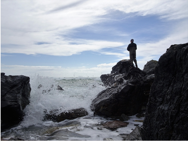
A client’s bass caught during the 3rd hour of the flood and when, significantly, the strength of the flow really began to increase. It is understanding why this might have occurred that I will expand on in this series.
In very simple terms, if you have two minutes to fill a bath up to a level of two centimetres, and then you have the same amount of time to fill a bath up to a depth of four centimetres then clearly you will have to increase the flow of water significantly to achieve this. This is precisely what happens in the sea - the flow or strength of current is increased and this can have a huge impact on the bass lure fishing.
Something to note is that the velocity of the tide is not constant, in that it doesn’t travel at the same speed throughout the flood and the ebb. The middle two hours (3rd and 4th if you like) is when you will experience the greatest amount of flow, which as you’ll read, can change the overall dynamics and fishing potential significantly.
To swim or not to swim
All throughout my teens, which is when I became utterly fascinated with bass, everything I read and everyone I spoke to told me to ‘look for tide.’ What they meant was to seek out areas affected by tidal movement and strong currents with headlands being high on the list. Over the years, although this advice is sound, what I’ve gradually learnt is that depending on the actual mark itself, and more especially the actual underwater topography in conjunction with the tidal range, will dictate whether bass move through quickly, slowly, hold and remain in position for quite long periods (minutes through to hours) or simply not be there at all!
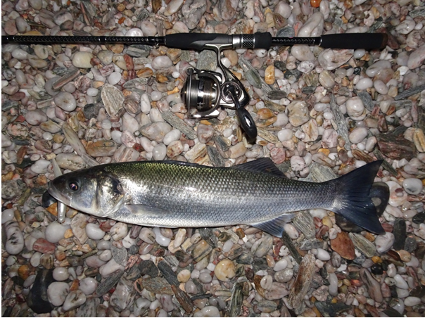
One of my many bass ‘marks’ within which I have only caught bass between certain tidal ranges (4.4-5.0m) one hour before high water. A powerful lateral flow runs here which means there could be an optimum level of tidal velocity and depth of water for bass to remain and hunt in during this period in the tide.
In my recently released book ‘The Lure of The Bass’ there is a whole chapter dedicated to the ‘Movement and Behaviour’ of bass. Understanding how they traverse around the coastline with the naturally flowing tide and how and precisely where they will ‘hold-up’ depend on the strength of the tide, in addition to size and shape of structure or feature whether it is protruding or completely submerged, is the first stepping stone to finding new marks or maximising the potential of your present ones.
I’ll leave you for now with this vital snippet that does go against some previous theories perhaps. I can say, categorically, that bass (more so the larger specimens) do like to move out of the flow of the tide completely. They do it in daylight, but I believe they are far more likely to do so under the cover of darkness...
In Part 2 alongside some specific occasions when I have utilised one bass lure type over another to extract a bass, or assist a client to land one when the zone in front of you appears devoid of them I will discuss who the wind and air pressure can alter the tide’s height.
Marc Cowling is a highly respected shore based guide who specialises in catching bass from the shore on lures.
Read Part 2.